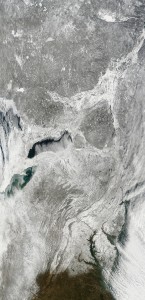
Here’s an excerpt from the 250 meter pixel version of the Terra/MODIS image taken at 01/03/2014, 15:55 UTC. ( The link shows the default 2km pixel image, but you can select pixel size at the left. ) 
The excerpt shows the southern end of the snow cover, just south of Washington, D.C., all the way up through New Jersey, Pennsyvania, and New York to Quebec and the frozen Lac Saint Jean, at top right. Note Lake Erie and Lake Ontario at left center, as well.
At the time of the image, southern New England was still under cloud cover to the right of the excerpt. A very impressive vista!
